Evolution of the Transportation System that serves Martha Lake
To gain an understanding of the development of the transportation system that now serves the Martha Lake area, it is necessary to review the pattern of settlement, the political currents and the national history that occurred during the last 170 years or so, that provided the catalyst for this evolutionary process. Prior to 1846, much of the original Oregon Territory was jointly occupied by the British, represented by the Hudson Bay Company at Fort Vancouver and Oregon City, and the United States, with the American Fur Company, owned by John Jacob Astor establishing a trading post at Astoria, Oregon in 1808. However, the early 1840’s marked a period of migration west that saw thousands from the eastern U.S. come across the heavily publicized Oregon Trail. The numbers coming west became so numerous that it resulted in the “Great Emigration of 1843”, and the numbers of U.S. citizens soon vastly outnumbered the British presence. In 1846, this massive imbalance resulted in the 1846 Treaty of Oregon which moved the northern boundary of the United States in the northwest to its present location, but was ambiguous as to the rightful ownership line through the San Juan Islands in Northern Puget Sound. The Washington Territory was split off from the Oregon Territory in 1853.
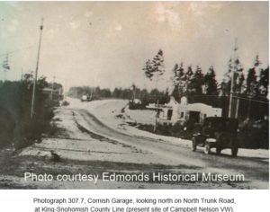
Meanwhile, in our general area, development had started initially in the Seattle area and on the west side of Puget Sound on the peninsula. Seattle was founded on November 13, 1851, by the Denny Party, and in 1852 John R. Thorndike and W. P. Sayward constructed a lumber mill at Port Ludlow, and in 1853, Pope and Talbot started a lumber mill and company town at Port Gamble to more efficiently create and transport lumber to the gold fields of California. They had originally been shipping lumber from Maine around Cape Horn; a much riskier and expensive proposition. On the west side of the sound, Mukilteo was settled in 1858, and Snohomish was first settled in 1859, and Edmonds and Everett didn’t come into being until 1876 and 1893 respectively. The primary means of transportation was by boat, with numerous independent firms operating numerous vessels collectively called the “Mosquito Fleet”. Even Snohomish, which was the county seat until 1897, was serviced by paddlewheel steamer. Until the early 1900s there was very little road development on the west side of the sound north of Seattle.
From WM. Whitfield, we have the following description: “It is not a paradox to say that the first road in Snohomish County was a river, for the great streams which have added so much to the wealth of the county afforded the best and the cheapest and the most convenient transportation that the pioneers could possibly have had. At the very first there was no object in and no incentive for penetrating the depths of the vast forest which covered nearly every inch of Snohomish County. There was at that time no place to go which could not be reached much more quickly and easily by water than by land.” . The first land highway was, therefore, not one built by the settlers for their own convenience, but one attempted by the Federal government as a military necessity. (8, Page 183)
The U.S. had two forts to protect the interest of the new arrivals: Fort Vancouver, just north of Portland, which was originally build by the British Hudson Bay Company, but passed to the U.S. with the passage of the Treaty of Oregon in 1846, and Fort Steilacoom just south of Tacoma, established by the U.S. Army in 1849. As the relations between the British and the U.S. still had times of friction, particularly in the San Juan Islands as a result of the non-violent conflict that culminated in the famous “Pig War”, and also to protect the settlers from attacks by Indians from Canada, Fort Bellingham was planned to protect the northern end of the territory and construction was started on August 26, 1856, under the command of then Captain George E. Pickett, detailed from Fort Steilacoom. Pickett later became a notable figure in the U.S. Civil War.
The Military Road:
It was also concluded that to connect the three installations and to provide for transportation of men and supplies between the installations not dependent upon water transport, that a Military Road should be constructed. Here, the story becomes rather interesting. “Motivated by the desire to open up the Puget Sound country, King County’s first major road was first proposed in 1852 by territorial legislator Arthur A. Denny. (1) The Washington Territorial Legislature applied to the Secretary of the Army, Jefferson Davis (who later became the President of the Confederacy) for funds to build the road, and Congress approved the sum of $35,000 in 1857, to survey and construct said Military Road.” (2) The road was to be located upon high ground and ridgelines where possible. Army troops were brought in to work with local pioneers to survey and begin construction. A number of junior army officers were assigned to this project. It should be recognized that being assigned to this endeavor in one of the more isolated portions of the United States was not considered to a a plum assignment, and the officers that were selected for this duty were not in any way the top graduates from West Point. However, one’s academic performance is not always a great predictor of one’s later career achievements. The junior U. S. Army officers that were assigned to this project included Ulysses S. Grant, Philip Sheridan, George McClellan, George Pickett, and Joseph Hooker, all of whom went on to gain fame or infamy in the U.S. Civil War: Grant, Sheridan, McClellan and Hooker on the Union side and Pickett and Jefferson Davis, obviously a senior officer, on the Confederate side. (4) The southern portion of the road was to be a corduroy road, built of felled, split trees laid crossways on the roadbed. However, only a five mile section just south of Seattle and a five mile section south on Bellingham ever met these standards. Much of the remainder was simply a crude trail.
“As documented in Meador’s pamphlet and “Building Washington: A History of Washington State Public Works,” by Paul Dorpat and Genevieve McCoy, published in 1998, Captain W.W. DeLacy began surveying the route in 1858 with a crew of nine, including six Native Americans. Construction began soon after under the supervision of Lt. George H. Mendell and reached Seattle in October 1860. In 1864, the first telegraph line was strung along the entire route.” (3) It passed through Olympia, Fort Nisqually, Fort Steilacoom and Fort Puyallup and was first travel by the Reverend Daniel Bagley and family. (1)
As shown on the excellent YouTube https://youtu.be/RLMki6mGBok : Karen Meador shows the route of the entire Military Road. From the Ballard area the route generally went up 15th Avenue to Holman Road, on to Northgate then followed the northern end of Lake Washington to eventually follow the current route Highway 9 on to Snohomish, to Lake Stevens, to Arlington and eventually returning to what is now I-5 near Mount Vernon before heading further north as shown on the following map. At first it seems odd that the Military Road, being a very critical artery, was sited well east of what is now the main corridor of commerce. However, in the late 1850s, Snohomish was the next major hub. (4) WM. Whitfield explains the situation very well: “ For the first half of its existence, after it became a land of the white men, Snohomish County pivoted about Snohomish City. For a third of a century, it was the county seat and the center of events of every kind. From 1860 to 1880, while here were settlers and logging camps and trading posts in other parts of the county, there was no real community life outside of Snohomish City. In the sparsely settled state of the Territory, moreover, Snohomish City was one of the outstanding towns of the Puget Sound area. Seattle was not a great deal larger, and no better facilities and no more luxuries. Whatcom, now Bellingham, was not nearly so large, in 1879 and 1880, as was the busy town below the forks of the Snohomish River.” (8)
To put this route in perspective, the following chart shows the populations of several of the major cities in Snohomish County at intervals during this era.
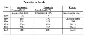
From this chart it is apparent why Snohomish was a logical target for the Military Road when it was planned in the late 1850s. It was the only settlement of any size in the vicinity. Abraham Lincoln was elected President in 1860, and with the commencement of the Civil War in 1861, the Regular Army abandoned both Forts Steilacoom and Bellingham and cut off further funding for the Military Road.
When the eastern power brokers headed by John D. Rockefeller, Charles L. Colby, and Colgate Hoyt, a director of the Great Northern Company, created the planned city of Everett just after the arrival of the Great Norther Railroad and almost forty years after the settlement of Snohomish, it quickly became the dominant municipality north of Seattle and hence the new focus of future road development. The town’s name of Everett came from Colby’s son Everett.
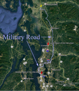
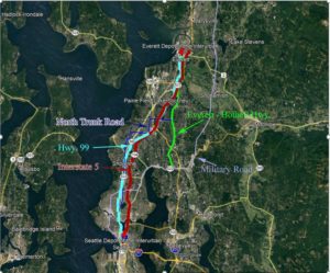
Route of the Military Road through the Seattle to Arlington area of Washington.
By the early 1900s, Seattle’s population had grown from 188 in 1860 to 80,671 and was poised for much more rapid increases in the decades following. Since Everett, Washington was now a major economic center a road system evolved to connect the two cities.
“In the 1880s Aurora Avenue began as a rough wagon road heading northward through dense forest. In September of 1884, Oak Lake Cemetery was founded by David Denny on the east side of 110th and Aurora. In 1893 Denny was forced to sell the cemetery due to a stock market crash where he had lost everything. The name of the cemetery was then changed to Washelli by the new owners.
In the early 1900s, a group of business people purchased the property on the west side of Aurora at 110th and tried to sell the land for a housing development. This development failed because it was too far out of town. In 1901, what is now Aurora Ave. became known as the R. F. Morrow Road. (5)
In the 1880s today’s Aurora Ave existed as a rough wagon road through the forest.
In 1911, Firlands Sanatorium for tuberculosis patients was established near the county line and a better road was needed to make it more accessible for staff and visitors coming from Seattle. Firlands Way latter became a section of the original North Trunk Road. By 1912, the two-lane North Trunk Road was extended from Green Lake to the county line making a more direct route to Everett than by taking the Pacific Highway through Lake City. By 1913, much of the North Trunk Road was paved with bricks. In 1919, the group of business people mentioned above that had attempted to sell land for a housing development, formed the Evergreen Cemetery. By 1927, the two competing cemeteries were merged to become the Evergreen-Washelli Cemetery. (5)
The Seattle-Everett Interurban Railway:
As discussed earlier in the history portion of this website, the Interurban was completed in 1910, incorporated as the Seattle-Everett Traction Company and covered 29 miles with nearly 30 stops, leaving on the hour and the half-hour from the Seattle and Everett Depots. The Interurban carried passengers during the day and freight at night. The Martha Lake Station was in the area just west of the current Ash Way Transit Station. The last run was in 1939. In its heyday, the Interurban provided the most efficient and heavily used mode of transportation between Seattle and Everett, and until 1916, with the construction of Everett-Bothell Highway, was the only practical method other than boat.
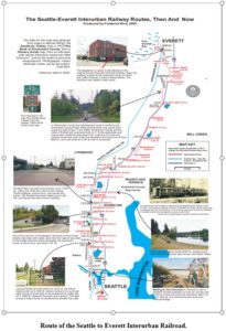
The Interurban route closely follows and parallels the routes later chosen for Highway 99 and Interstate 5.
As the entire region was logged over between 1900 and 1920, there were numerous old rail beds and logging roads throughout the region, but the road quality was very low and without maintenance deteriorated further, rapidly.
To get a handle on the transportation system that developed from this point on, it would be advised to clear your mind of the major highways that we now use so frequently. We can start with the North Trunk Road.
The North Trunk Road System:
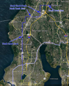
The following is not fully confirmed but appears to be a good starting point. The North Trunk Road started out on Westlake Avenue to Fremont Avenue, then north on Fremont to 50th, then left on 50th to Phinney Avenue, then north as it turns into Greenwood Avenue, then it continued north on Greenwood to 85th, turned right on 85th, then east to Aurora Avenue. The North Trunk Road then continued north to N. 185th and veered to the left on Firlands Way N., then continued north on Firlands Way, then back to Aurora Avenue, just past 195th. It then continued north to 212th St. SW. (Aurora Avenue ended at what is now Aurora Village, so the route follow by the North Trunk Road was north on 84th up to 212th, to what is now known as “Five Corners) Then it turned right and continued east on 212th to 76th Avenue W., then turned left and continued north on 76th St. SW. Then turned right onto 196th and continued east to 36th Avenue W. The road then turned left onto 36th and continued north to 164th St. Sw. Then it turned right onto 164 and continued east to the Pacific Hwy (now called the Everett Bothell Highway at Mill Creek, and then north to Everett. (From Email from Betty Gaeng, August 11, 2021)
All of the road to this point, despite the jog after Five Corners appears to have been called simply the North Trunk Road, and on some early maps, the name was not capitalized. What the author now writes is based on supposition. As mentioned above, the entire route was originally called the North Trunk Road. The author’s guess is that as the area developed and the population grew and new roads were added and improved the the original name became a bit confusing and that further direction indicators were added to appropriate portions of the original road system. The segment on 196th Street SW between Vaughn’s Corner and 36th Avenue West was named North Trunk West. The route then turns north again on 36th Avenue West to 164th Street SW and was called North Trunk North, and the next section on 164th Street SW past Martha Lake and on to the intersection of the Everett-Bothell Highway (Wintermute’s Corner) was North Trunk East. On this section of North Trunk East, just east of where Highway 99 is now located, was a portion known as Gooseneck Way. “The road had this odd shape like the head of a goose because it was an overpass for the logging roads in the area. It was just a short distance east of what later became Keeler’s Corner. This strange road configuration is shown on several early maps of the area.” (Email from Betty Lou Gaeng in January 2021.)
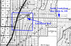
Gooseneck Way Portion of North Trunk East.
After 1916, and the construction of the Everett-Bothell Highway, if one wanted to drive from Seattle to Everett, one could follow the North Trunk Road system just described, to Wintermute’s Corner, then continue on the Everett-Bothell Highway into Everett. Another option was to head out of Seattle via Lake City, on to Bothell, then follow the entire route of the Everett-Bothell Highway into Everett. Both options are obviously much less direct, but the route now followed by Highway 99 from the King/Snohomish County line northward didn’t come into existence until 1927. “People traveling to the Martha Lake area from Seattle, were more likely to travel via the original Pacific Highway, i.e., by way of Bothell. Of course, by that time the Bothell/Everett Highway was no longer called the Pacific Highway. The Bothell/Everett highway was a more direct route and easier traveling. When the Puget Mill agent showed our family the farm my folks bought back in 1933, it was via the Bothell/Everett Highway and the posted Gateway at Wintermute Corner to Alderwood Manor off the highway past Martha Lake to what is now Old Manor Way. We moved from Seattle to our farm just a short distance west of Lake Stickney by way of the Martha Lake Road (North Trunk Road East). It was an easier route than newly opened Pacific Highway (99).” (From Betty Gaeng email, 8/11/2021)
Cheri Ryan, Director of the Lynnwood – Alderwood Heritage Center, mentioned that her father who had been both a delivery man and fireman in the area in the 1950s and later, recalled that Poplar was North Trunk South.
Many of the directional names later applied still need to be confirmed from reliable regional maps and atlas, but in this time of Covid and closure of many of the archives, that has yet to be done
Edmonds Access to the North Trunk Road
“Edmonds gained access to the North Trunk Road when county commissioners awarded a contract for a cut-off road connecting the end of the North Trunk Road to Edmonds in August 1915. Despite the increasing number of automobiles and the need for good roads, many still opposed its progress, including one County Commissioner, Al Rutherford, who reportedly said, “Why, it doesn’t commence anywhere or end anywhere, and but a few would ever use it.”
The history of this section of road from the old Edmonds ferry dock location to the intersection of what is now Highway 99 and State Highway 104 (near the old Aurora Mall location) and on to Lake Washington on via State Route 104 to Lake Forest Park, has an interesting history of its own as provided by Betty Lou Gaeng in an article published in the Beacon “By George: A Brackett mystery solved.”
“In 1876, when George Brackett paid $650 and obtained his 140.75 acres of land that became Edmonds, he purchased the property from Morris Frost and Jacob Fowler, two businessmen from Mukilteo. The acreage had originally been the pre-emption claim of Pleasant H. Ewell. In 1870, when a storm forced George Brackett to land his canoe on the shore of the Frost and Fowler property, he found a man by the name of Daniel Hines working at a small one-man operation making shakes and shingles.
Ewell started his business in the 1860s. In order to get his shakes to market, Ewell blazed a rough wagon road southeast through the woods to Lake Washington. From that location he was able to get a larger marker for his wares.”
Edmonds’ Ninth Avenue was graded and graveled in late 1925, and in 1930 the city announced plans to spend $10,000 on the extension of Main Street to connect with the North Trunk Road at Five Corners. Today, more than a few travel the old North Trunk Road route as we know it: Aurora Avenue and Highway 99.” (5)
The North Trunk Road System.
The Everett-Bothell Highway:
The Everett-Bothell Highway was completed in 1916 as part of the intercity Pacific Highway and briefly formed part of U.S. Route 99 in 1926. This highway provided a relatively direct route between Bothell and Everett, and the northern portion of the Everett-Bothell Highway from Wintermute’s Corner where North Trunk East connected to the Everett-Bothell Highway was the route to Everett from Seattle prior to the construction and relocation of the Pacific Highway.
The Pacific Highway, aka Highway 99:
In 1909, the Washington State Legislature envisioned a north-south highway from Blaine to Vancouver and authorized a survey to accomplish this. The Legislature designated a collection of existing roads and trails along the route as the Pacific Highway, but the construction and maintenance of the highway was the responsibility of the counties and entities through which the highway passed, leading to a variety of paving methods and conditions. Some portions were dirt, some paved with concrete and in some sections brick was the surface of choice. In 1923, the preliminary design was approved, and by October 26, 1927, the new paved highway, 27.6 miles long, connected Everett to Seattle; a route 4 miles shorter than the old route through Bothell, and much straighter and safer. In 1927, the designation of U.S. 99 was moved west to the new Pacific Highway that would later become modern day SR 99. (6)
Interstate 5:
The most recent piece of the transportation puzzle was the construction of Interstate 5 through Snohomish County, that when completed provided an interstate highway from the Canadian border to our southern border with Mexico. The Interstate Highway System was commenced under the Eisenhower Administration with the passage of the Federal-Aid Highway Act of 1956, which provided 90 percent funding for a nationwide network of high-speed, limited access roads. In January 1967 the final freeway section from Everett to Tacoma was completed, linking the greater Seattle metropolitan area. Ironically, through the Martha Lake area, the route follows a portion of the original Interurban Line that was used so heavily between 1910 and 1939 before it became obsolete.
Link Light Rail:
Now, to come full circle, as this is being written in January of 2021, a rapid rail line is being constructed parallel to I-5 in the Martha Lake area under the auspices of Sound Transit that will eventually link much of Snohomish, King and Pierce Counties with a rapid rail system. This system is closely adhering to the I-5 corridor.
Time Line of Road Construction in the Seattle
- 1858 to 1864 : the Military Road was surveyed and constructed connected Fort Wancouver to Fort Bellingham.
- 1880s: Aurora Highway, the very southern part of what later becam the North Truck Road System, was a crude wagon road as far north as to what is now the Evergreen – Washelli Cemetery.
- 1910: the Interurban started providing service between Seattle and Everett for both passengers and freight, with a stop at the Martha Lake Station.
- 1912: The North Truck Road was extended to the King-Snohomish County line.
- 1915: A cut-across road was built from what is now the intersection of Highway 99 and Highway 104, the old Aurora Mall location down to Edmonds.
- 1916: The Everett Bothell Highway was constructed. It became part of Highway 99 in 1926, but in 1927, the more direct and current route of Highway 99 was completed.
- 1925: The City of Edmonds extended Main Street in Edmonds to Five Corners to a more northerly tie into the North Truck Road.
- January, 1967, the final section of I-5 is completed between Tacoma and Everett.
- Link Light Rail project owned by Sound Transit, began operations on August 22, 2003, and when completed will extent from Tacoma to Everett, Washington, with an East Link Extension connecting to Bellevue and Redmond.
List of References:
- https://www.start-wa.com/western_wa_travel.html
- https://qahistory.org/military-road/
- https://sococulture.org/where-is-our-military-road/
- https://youtu.be/RLMki6mGBok
- http://www.pacific-hwy.net/aurora.htm
- https://myedmondsnews.com/2013/10/month-edmonds-history-north-trunk-road/
- https://www.historylink.org/File/21021
- History of Snohomish County, WM.Whitfield Supervising Editor, Volume 1, Illustrated, Pioneer Historical Publishing Company, Chicago – Seattle, 1926.